Unmanned aircraft crews now have a dedicated bit of New Zealand airspace in which to test their cutting-edge aircraft. For the rest of us, this is yet another story about the need to check NOTAMs.
New Zealand’s latest initiative to consolidate its place in the global aerospace industry is the introduction of special use airspace over Kaitorete Spit, 35KM from downtown Christchurch.
Kaitorete – a 25KM long finger of land extending west from Banks Peninsula – has been used for about four years by advanced aviation operators to launch and test their aircraft.
But with each test, those aerospace operators would first have to submit applications to the CAA for temporary ‘special use airspace’ – SUA – over the Spit.
It was a long process as they answered questions about how much airspace was needed, how they were going to manage separation from other traffic, the surface they’d be operating over, and the airspace they’d need to be flying in.
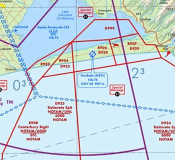
The airspace has now been designed as six permanently designated restricted areas, extending 12NM out from the Spit – and six permanent danger areas extending out seaward to 110NM. In total, the 12 SUA areas cover 26,000 square kilometres.
The restricted areas allow the administering authority, the Tāwhaki National Aerospace Centre (TNAC), to manage entry into and exit from the area, and manage the operations of aircraft while inside the area.
The danger areas let airspace users know there’s a potential risk to flying there.
But the areas are not permanently active. One, or some, or all of these areas – depending on the operational area required – will be activated by NOTAM, to the altitude required for the particular activity, for the days and times they are needed.
Not for operational use. VNC C20 effective 27 November 2025.
John Holt, Tāwhaki Executive Director, says the advanced aviation operators now have access to airspace that’s safe, flexible, and robustly managed.
“Each time they want to run a test flight campaign, they will obviously save time and resources,” he says.
And while the SUA is undoubtedly a boon to New Zealand’s growing $3b aerospace industry, Steve Smyth, Head of the CAA’s Emerging Technologies Programme, says safety at the site and adjacent test airspace, remains absolutely critical.
“Creating this dedicated airspace is as much about safety as it is about gaining important test data. In particular, local pilot awareness that dynamic testing is being conducted on a regular basis at the TNAC site, and potentially well out over the sea, will contribute significantly to keeping these activities safe.”
John Holt, who is himself a recreational pilot, says what’s needed from traditional pilots flying in the area, is a “maintenance of standard operating procedures”.
“Before you fly, check the flight information from your local club or aerodrome, but, critically, check NOTAMs. These will be published 24 hours in advance of any danger or restricted area being activated.”
There are some operators who’ve negotiated with TNAC to be able to fly in the airspace, even with activated restricted and danger areas.
“It’s a question of communication,” says Steve Smyth. “We know that TNAC has developed procedures to enable communication between all parties should short-notice penetration of the airspace be necessary. For example, in an emergency situation, or when a rescue helicopter requires immediate access.”
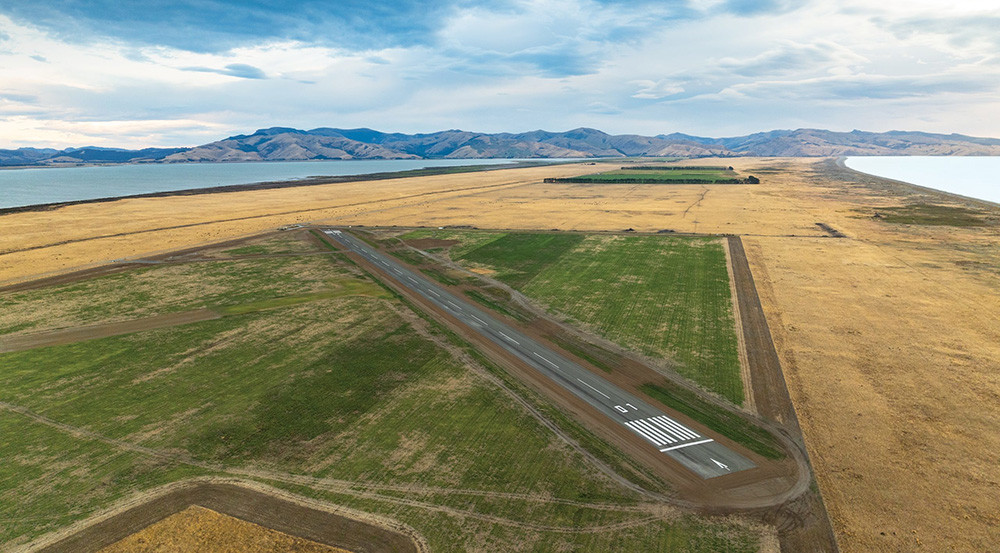
The TNAC site, which includes a 1KM sealed runway and hangar, was established to support emerging technology research and development activities, enabling trials and testing for leading-edge advanced aviation and aerospace endeavours. Photo courtesy of Tāwhaki National Aerospace Centre.
John Holt is not expecting any drama from traditional pilots unintentionally wandering into the activated airspace.
“In our six to seven months preparation for the launch of the permanent SUA, we’re yet to have anybody seriously encroach on these areas.”
John says an AWIB-type system (although without the weather information) has been established with a repeated message to let pilots know when the airspace will be active.
When it has been activated, ‘Tāwhaki Operations’ will use the same frequency (130.025 MHz) to communicate with pilots and let them know what’s going on.
One of the leaders in the country’s aerospace development sector, Kea Aerospace, says the more streamlined process means the company, and the CAA, “…don’t have a bunch of work, re-doing these permissions every few months.
“It’s pre-approved, pre-defined, permanently designated, and activated every now and again,” says Phillip Stott, Kea Chief Operations Officer.
“We’ve been conducting flight testing of UAVs at Kaitorete since 2021, with visual line of sight tests then beyond visual line of sight tests.
“We’ve made extensive use of temporary danger areas over the last couple of years and found that activation via NOTAM was pretty effective in alerting other airspace users to those UAV activities.
“Very occasionally, we’ve had GA traffic enter the activated SUA, not so much because the pilot had made a risk-based decision, which is permitted for a danger area, but because they weren’t aware of the NOTAM.
“With the aid of our visual observers, ADS-B, and radio, we’ve been able to have a friendly interaction to mitigate any potential conflict.”
Phillip says there are significant and additional safety benefits of the new SUA.
- The restricted area portion of the SUA should mean that separation of UAV activity from other airspace users is more robust.
- Greater use of the SUA by multiple organisations will normalise the activity and thus will be expected by other airspace users.
- Being permanent SUA – that’s active when advised by NOTAM – it will now be published on the applicable visual navigation chart, providing another source of information for airspace users during flight planning.
Phillip says the development of the SUA is creating a bright future for clients like Kea Aerospace, but he cautions there’s a responsibility on everyone to be vigilant, including always checking NOTAMs.
More information
- Six restricted areas (RA) – five RAs to be active from surface to 6000ft AMSL, one RA to be active surface to 3500ft AMSL.
- Six danger areas (DA) – three DAs to be active from surface to UNL (unlimited), and three DAs to be active from 6000ft to UNL. The three DAs active from 6000ft to UNL are laterally coincident with five of the proposed RAs.
- The three DAs active from surface to UNL include one small DA to the north and two DAs to the south-east extending seaward from the 12NM territorial sea limit.
- All RAs and DAs are active by NOTAM only.
Between now and November, check the AIP Supplement(external link). In November the SUA will be permanently charted on the VNC and enroute charts.
Footnote
Main photo courtesy of Tāwhaki National Aerospace Centre